November 23, 2025 | 18:27 GMT +7
November 23, 2025 | 18:27 GMT +7
Hotline: 0913.378.918
November 23, 2025 | 18:27 GMT +7
Hotline: 0913.378.918
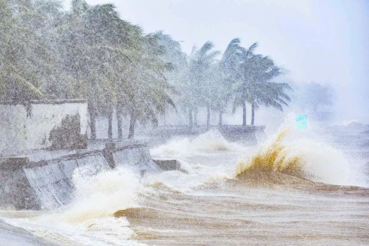
According to Mr. Mai Van Khiem, Director of the National Center for Hydro-Meteorological Forecasting, on the afternoon of July 22, after Typhoon Wipha made landfall in Vietnam, the Gulf of Tonkin (including the special administrative regions of Bach Long Vi, Co To, Van Don, Cat Hai, Hon Dau Island, and Hon Ngu Island) experienced strong winds of level 6-7, gusting to level 10 near the eye of the storm. Sea waves were 2-4m high, with very rough seas.

Waves were strong at Hai Tien beach (Thanh Hoa) at noon on July 22. Photo: Quoc Toan.
On the afternoon of July 22, due to the lingering effects of Typhoon Wipha, the coastal area of Hung Yen province experienced strong southeast winds, pushing water towards the shore. Coastal stations and estuarial areas saw water levels rise by nearly 1m. At the Ba Lat hydrological station (Hung Yen), water rose by 0.8m, with the highest water level reaching 297cm (surpassing the historical level of 2017 by 26cm). At the Dong Quy hydrological station (Hung Yen), water rose by 0.6m, reaching 244cm, and continued to rise.
The circulation of Typhoon Wipha is causing widespread heavy rain in the Northern and North Central regions. Total rainfall from 7 AM on July 21 to 1 PM on July 22 exceeded 300mm in many places. Particularly in Thanh Hoa, Nga Son stations recorded 412mm of rain, Sam Son 380mm, Trieu Son 336mm, Nhu Thanh 327mm, Ba Dinh 326mm, and Hac Thanh 315.8mm. In Ninh Binh, Hai Anh, Giao Linh, and Tam Diep stations, over 260mm of rain was observed. Some coastal areas like Van Don (Quang Ninh) and Cat Hai (Hai Phong) exceeded 180mm.

People disregarded danger to collect firewood at Ke Coc dam, Chau Tien commune, Nghe An province, on the afternoon of July 22. Photo: Dinh Tiep.
During Typhoon Wipha, the strongest winds recorded at sea were in the Bach Long Vi special administrative region (Hai Phong), strong at Alert Level 10, gusting to Alert Level 12. The coastal area of Tien Yen (Quang Ninh) had winds at Alert Level 10, gusting to Alert Level 14.
Due to heavy local rain, some roads and residential areas in the Ninh Binh and Thanh Hoa provinces experienced localized flooding. Prolonged heavy rain increases the risk of inundation, flash floods, and landslides. Currently, water levels in the upstream Nam Non River (Laos) and the inflow to the Ban Ve hydropower reservoir (Nghe An) are forecast to increase in the coming days. The center urges units to closely monitor developments, adjust operations in a timely manner, and proactively ensure safety downstream.
It is forecast that from the afternoon of July 22 to the afternoon of July 23, the typhoon will gradually weaken into a low-pressure area, causing rain along its path towards upper Laos.
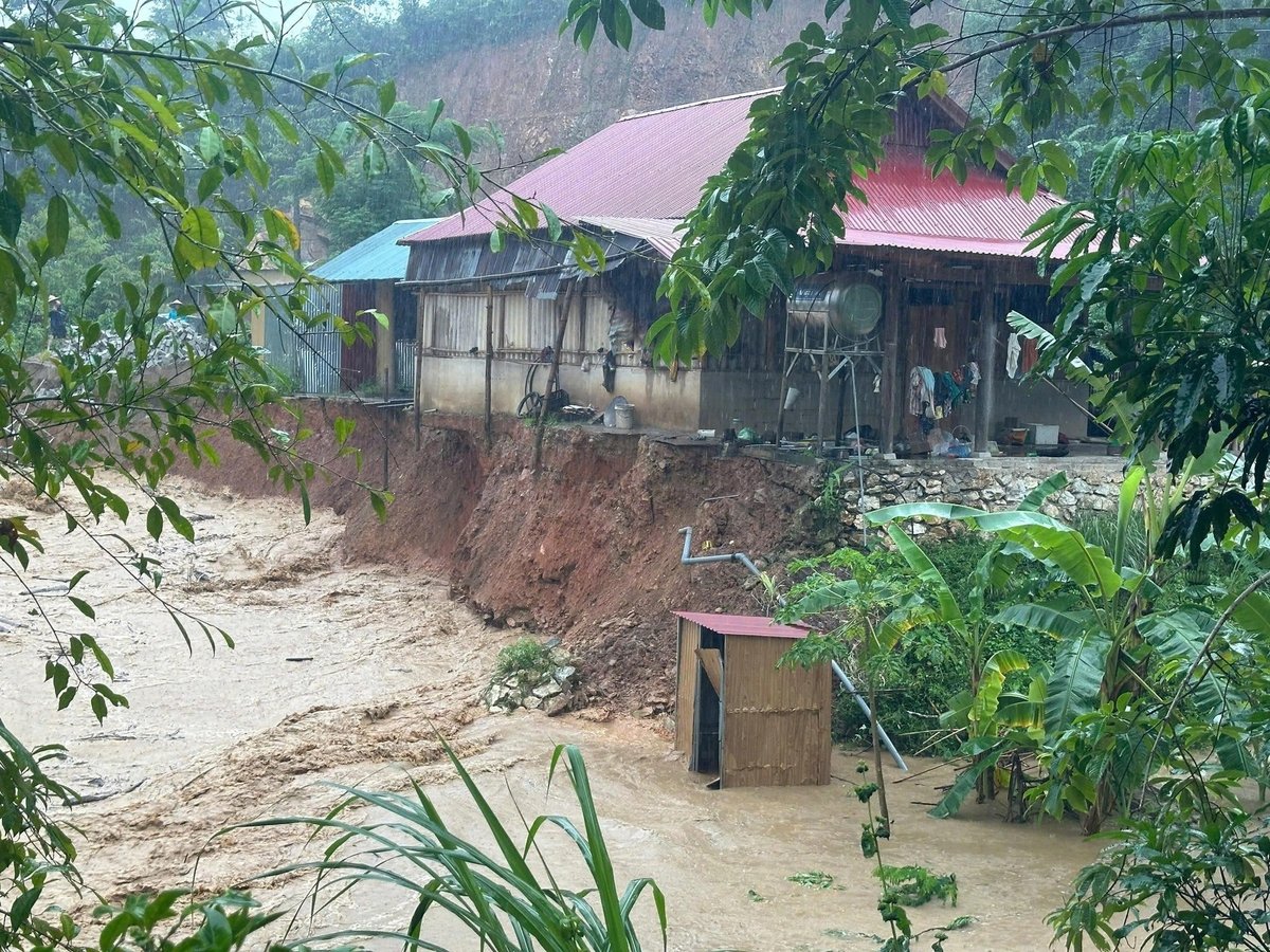
After the typhoon winds pass, the biggest concern is the risk of flash floods on small rivers and streams and landslides on slopes. Areas with a high risk level include mountainous and midland regions of Northern provinces, Thanh Hoa, Nghệ An, and Ha Tinh. "Special attention should be paid to the western mountainous communes of Thanh Hoa and Nghe An provinces, as these are the rainfall centers during this typhoon," emphasized Mr. Mai Van Khiem.

Nhon Mai commune (Nghe An province) experienced flash floods on July 22. Photo: Dinh Tiep.
It is forecast that from the afternoon of July 22 to the morning of July 23, Thanh Hoa, Nghe An, southern Phu Tho province, and Son La will experience heavy to very heavy rain and thunderstorms. Widespread rainfall is expected to be 60-120mm, with some localized areas receiving over 200mm.
Other areas in the northern region and Ha Tinh will experience rain, moderate rain, with some localized heavy rain and thunderstorms. Rainfall amounts will be 20-40mm, with some localized areas exceeding 100mm. The hydrometeorological agency warns of the risk of high-intensity rainfall exceeding 150mm within 3 hours. Heavy rain in a short period can cause flash floods, landslides in mountainous areas, and inundation in low-lying areas.
From July 22 to July 25, floods are forecast to rise on the Ma River and Ca River with a range of 3-6m. During this flood event, peak flood levels in the upstream areas of these rivers are likely to reach Alert Level 1-Alert Level 2 and above Alert Level 2. Peak flood levels in the downstream Ca River will reach Alert Level 1-Alert Level 2; downstream Ma River will remain below Alert Level 1.
Translated by Linh Linh

(VAN) Applying green technology in rural water supply and sanitation helps improve resource efficiency, protect the environment, and enhance community living standards.

(VAN) Developing biosecure livestock production is the key that helps Tuyen Quang form linked chains in livestock production and build its brand in the market.

(VAN) During his bilateral activities in South Africa, Prime Minister Pham Minh Chinh welcomed Vice President of the South African Chamber of Commerce and Industry Neil Pollock.

(VAN) Prof. Dr. Hoang Van Cuong, National Assembly Deputy of the 14th and 15th terms, shares recent pioneering policy decisions.

(VAN) Deputy Minister Tran Thanh Nam directed a comprehensive reform of the agricultural extension system, emphasizing professionalism and connecting farmers with the market.
/2025/11/22/3633-1-072521_760.jpg)
(VAN) The signing ceremony took place under the witness of Prime Minister Pham Minh Chinh and President of the Republic of South Africa Cyril Ramaphosa.

(VAN) Severe flooding in Khanh Hoa Province has caused catastrophic damage estimated at around USD 30 million, with the agriculture and irrigation sectors alone accounting for roughly USD 15.7 million in losses.