November 19, 2025 | 02:29 GMT +7
November 19, 2025 | 02:29 GMT +7
Hotline: 0913.378.918
November 19, 2025 | 02:29 GMT +7
Hotline: 0913.378.918
After making landfall, it will move further inland and weaken into a tropical depression.
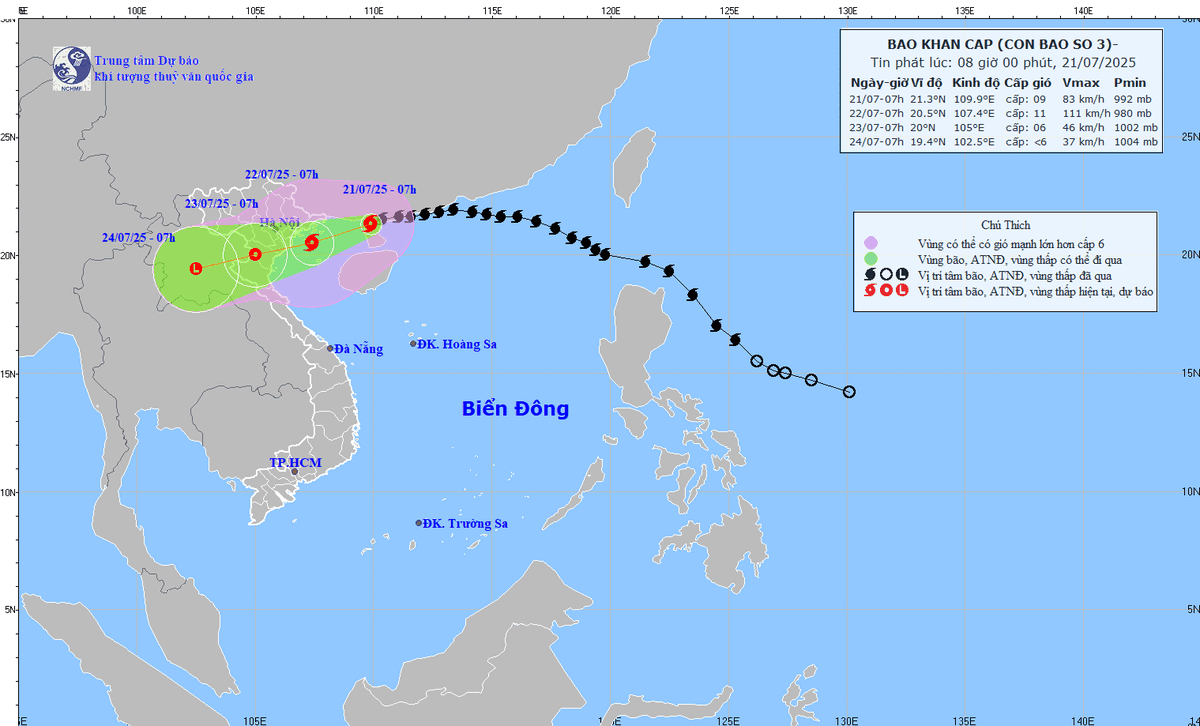
As of 7 AM today (July 21), Tropical Storm Wipha (locally known Typhoon No. 3) was located over the northern part of Leizhou Peninsula (China), approximately 220 km east of Quang Ninh - Hai Phong.
The strongest sustained winds are currently at Category 9 (75-88 km/h), three categories lower than yesterday morning, July 20. The storm's forward speed has also slowed to 15-20 km/h. However, the storm is expected to intensify again as it enters the Gulf of Tonkin, with maximum sustained winds reaching Category 11.

Tropical Storm forecast for the next 24-72 hours. Photo: National Center for Hydro-Meteorological Forecasting (NCHMF).
Throughout the morning of July 21, the Gulf of Tonkin is experiencing thunderstorms. Bach Long Vi Island recorded gusts of Category 8, while Phu Quy Island saw southwesterly winds of Category 6, gusting to Category 9-10. Song Tu Tay Station reported gusts of Category 7, and Huyen Tran Station had strong winds of Category 6, gusting to Category 9.
For the rest of today (July 21), scattered showers and thunderstorms are forecasted for many sea areas, with the potential for tornadoes and strong gusts. This includes the Gulf of Tonkin, the northern East Sea (including the Hoang Sa), the waters from Lam Dong to Ca Mau, the waters from Ca Mau to An Giang, and the Gulf of Thailand.
The National Center for Hydro-Meteorological Forecasting anticipates the northwestern part of the northern East Sea will experience winds of Category 7-8, gusting to Category 10, with waves 3-5m high and rough seas.
The northern Gulf of Tonkin will see winds of Category 6-7, increasing to Category 8-9. Near the storm's center, winds will reach Category 10-11, gusting to Category 14, with waves 3-5m high and extremely violent seas.
The southern Gulf of Tonkin will have winds of Category 6-7, with areas near the storm's center reaching Category 8-9, gusting to Category 11. Waves will be 2-4m high, resulting in very rough seas.
Sea conditions are extremely dangerous and unsafe for all types of vessels, aquaculture rafts, and coastal structures. Strong winds, high waves, and rising sea levels increase the risk of capsizing, destruction, and flooding.
Local authorities should be aware that coastal areas from Hung Yen to Quang Ninh may experience storm surges of 0.5-1m. Water levels at Hon Dau (Hai Phong) could reach 3.7-4.1m; at Cua Ong (Quang Ninh), 4.4-4.8m; and at Tra Co (Quang Ninh), 3.6-4m. There is a high risk of coastal and estuarial flooding in the afternoon of July 22.

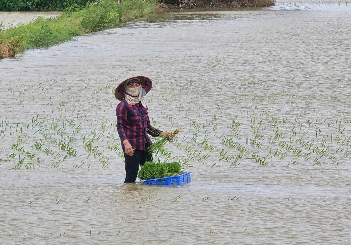
Rice farms in Hai Phong are at risk due to prolonged flooding.
Inland, from tonight, July 21, coastal areas from Quang Ninh to Nghe An are expected to experience strong winds of Category 7-9, with areas near the storm's center reaching Category 10-11, gusting to Category 14. Further inland, winds will be Category 6, gusting to Category 7-8.
Between late morning and midday on July 22, the storm will land in the provinces from Hai Phong to Thanh Hoa, then move further inland and weaken into a tropical depression.
Due to the storm's circulation, the Gulf of Tonkin, coastal and offshore central regions will experience strong winds of Category 7-8, later increasing to Category 9-10, gusting to Category 11-12. Coastal areas from Quang Ninh to Thanh Hoa will have strong winds of Category 8-9, gusting to Category 10-11, while inland areas will see strong winds of Category 7-8, gusting to Category 9-10.
From July 21-23, the Northeast, Northern Delta, Thanh Hoa, and Nghe An are forecasted to receive 200-350mm of rain, with some areas exceeding 600mm. Other regions of the North and Ha Tinh will receive 100-200mm of rain, with localized amounts over 300mm.
There is a high risk of heavy rainfall exceeding 150mm within 3 hours, as well as flash floods, landslides in mountainous areas, and deep flooding in low-lying areas.
Translated by Linh Linh

(VAN) Deputy Prime Minister Tran Hong Ha convened a meeting with the MAE and relevant agencies to discuss the draft decree on national multidimensional poverty standards for the 2026 - 2030 period.

(VAN) The year 2025 marks the 10th anniversary since more than 190 countries adopted the Paris Agreement on climate change, paving the way for strengthened global action.

(VAN) The PepsiCo Foundation funded the project ‘New Harvest: Sustainable Agriculture Initiative’, focusing on regenerative agriculture and climate change.

(VAN) Dr. Nguyen Viet Hung, ILRI's Regional Director for Asia, emphasized the One Health approach in ensuring food safety and reducing antimicrobial resistance risks in livestock.

(VAN) The youth-driven initiative ‘Innovate for water, act for the future’ seeks practical, scalable solutions to Vietnam’s water challenges.

(VAN) At the Annual Science Conference of Thuyloi University, Deputy Minister Phung Duc Tien directed researchers to focus on in-depth studies, data harmonization, and solutions linked to real-world practice.

(VAN) After nearly four years of implementation, 5,187 community agricultural extension groups have been established nationwide, with 47,493 members participating.