December 30, 2025 | 22:24 GMT +7
December 30, 2025 | 22:24 GMT +7
Hotline: 0913.378.918
December 30, 2025 | 22:24 GMT +7
Hotline: 0913.378.918

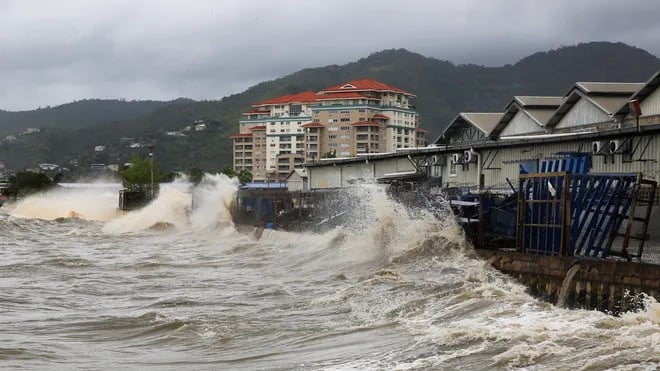
Hurricane Beryl strengthens to category 5, threatens to devastate the Caribbean. Photo: USA Today.
Hurricane Beryl has intensified rapidly, escalating from a Category 1 hurricane to a Category 4 storm in less than 10 hours. It has now reached Category 5 strength and is moving across the eastern Caribbean, approaching Jamaica. The storm is expected to cause severe damage, including power outages and flooding in many areas.
Forming earlier and more intensely than usual for this year’s Atlantic hurricane season, Hurricane Beryl could signal an unusual hurricane season due to the record-breaking temperatures in the Atlantic. The storm currently has winds of up to 260 km/h and is moving at a significant speed. Forecasts predict that the storm could bring 10 to 20 cm of rain on July 3, with some areas receiving up to 30 cm.
Jamaica has been under a hurricane warning since Monday. Tropical storm warnings have also been issued for the southern coasts of the Dominican Republic and Haiti. Residents on other islands in the eastern Caribbean have been preparing by securing their windows, stocking up on food, and fueling their cars ahead of the storm.
Mexico has also begun preparations for Hurricane Beryl, with federal authorities urging people to exercise “extreme caution.” Officials are currently assessing the damage caused by heavy rains from Tropical Storm Chris in the states of Oaxaca and Veracruz.
On the island of Tobago, a hotel and tourism group reported limited damage to hotels. Curtis Douglas, president of the All Tobago Fishermen’s Association, stated that the east side of the island suffered the most damage and that the seas remain dangerous. Fishermen were given adequate warning and were able to secure their boats.
Global warming has driven temperatures in the North Atlantic to all-time highs, increasing surface evaporation, which in turn fuels more intense storms with higher wind speeds. In May, the U.S. National Oceanic and Atmospheric Administration predicted higher-than-normal hurricane activity in the Atlantic this year, noting that ocean temperatures were unusually high.
Translated by Quynh Chi

(VAN) Located in three former provinces, Nam Dinh, Thai Binh, and Ninh Binh, and now in two provinces, Ninh Binh and Hung Yen, "Red River Delta" is the name of Vietnam's first interprovincial coastal wetland World Biosphere Reserve.
/2025/12/29/1046-1-210728_624.jpg)
(VAN) In 2025, Viet Nam recorded severe and extreme disasters, breaking multiple historical records and causing heavy losses in lives, property, and infrastructure nationwide.

(VAN) Applied technologies, water-saving irrigation is a strategic solution to promote climate-resilient agriculture and strengthen water security in the uplands.
/2025/12/29/3936-3-163422_251.jpg)
(VAN) Can Gio mangrove forest in particular and the entire Can Gio Mangrove Biosphere Reserve in general hold great potential for carbon credits.

(VAN) Chu Pah Rubber has announced its products that comply with the EU Deforestation Regulation (EUDR), affirming its commitment to sustainable production and product origin transparency.

(VAN) Deputy Director Nguyen Hoai Nam stated that a digital data platform will be developed with agricultural sector databases, utilizing AI to help farmers make informed decisions on 'watering correctly, sufficiently, and efficiently.’
/2025/12/29/4841-2-134224_777.jpg)
(VAN) From only about 10 individuals in 2009, the wild elephant population in Dong Nai has recovered to nearly 30 animals after more than 10 years.