October 23, 2025 | 23:56 GMT +7
Hotline: 0913.378.918
![]()
October 23, 2025 | 23:56 GMT +7
Hotline: 0913.378.918
![]()
According to the National Center for Hydrometeorological Forecasting, several provinces and cities are at risk of landslides and sudden floods due to continuous rainfall. The provinces of Phu Tho, Tuyen Quang, Dien Bien, Son La, Hoa Binh have seen different levels of rainfall from moderate, heavy to very heavy such as Muong Te town (Lai Chau) and Phu Loc (Phuc Tho) 134,6mm, Thien Kien (Tuyen Quang) 119.4mm, Huoi Leng (Dien Bien) 116mm, Bon Phang (Son La) 103,4mm, Tu Ly (Hoa Binh) 97mm among others.
In certain regions of the provinces of Lai Chau, Son La, Dien Bien, Hoa Binh, Phu Tho, Lang Son, Quang Ninh, Thanh Hoa, and Nghe An, a model of soil humidity indicates that the moisture content of the soil was nearly 90 percent saturated or approaching saturation.

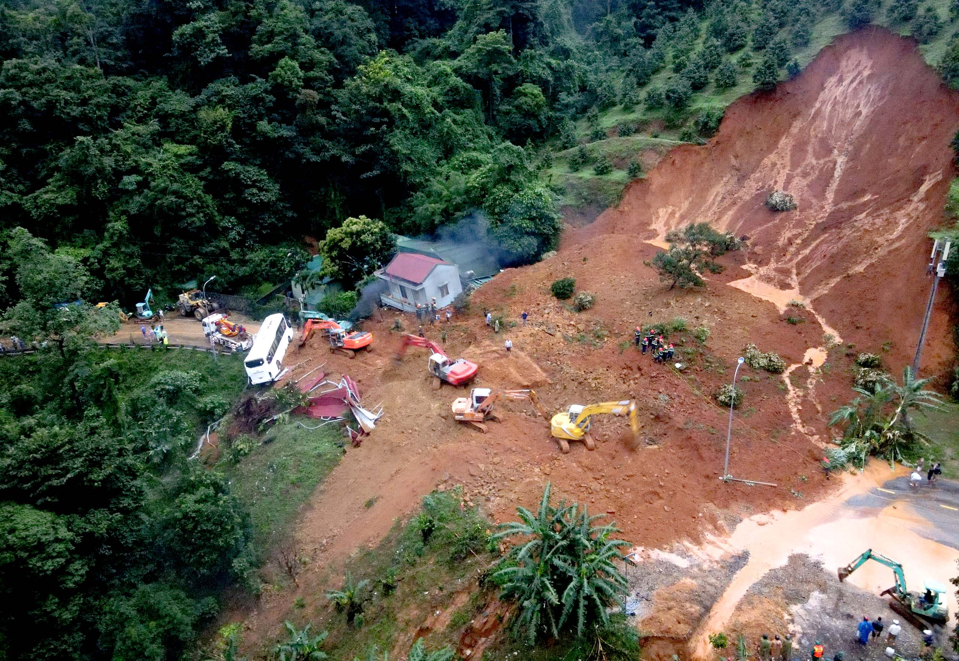
Heavy rain causes landslides in Mai Chau district (Hoa Binh province). Photo: CACC.
In numerous districts, there is a high risk of flash floods on rivers and small streams and landslides on steep slopes. Level 1 hazard alert for sudden floods, landslides, and land subsidence caused by rain, flooding, or discharge.
Flash floods and landslides can have negative effects on the environment and endanger human life by causing local traffic congestion and disrupting vehicle circulation, destroying civil and economic constructions, and causing damage to production activities and socioeconomic activities.
In Hoa Binh, the district of Da Bac, Hoa Binh City, and Luong Son receive between 40 and 70 mm of precipitation, while the communes of Doc Lap (Hoa Binh City) receive 41.8 mm, Lam Son commune (Luong Son) receives 33 mm, Tu Ly commune (Da Bac) receives 45.8 mm, and Da Bac town receives 44 mm.
High risk of flash flooding on minor rivers and streams, particularly landslides, land subsidence on slopes, roads, and areas with weak geology, and inundation of low-lying areas in urban districts. The risk of landslides is significant in the communes of the districts of Luong Son, Da Bac Mai Chau, Hoa Binh, etc.
The scene of a landslide on Bao Loc Pass (Bao Loc City, Lam Dong) on July 30. Photo: Minh Hau.
There is a risk of flash floods and landslides in areas of Son La province where the soil is almost saturated (over 90 percent) or has attained the state of saturation due to continuous torrential downpours.
The meteorological agency warned of the risk of flash floods on rivers and small streams and landslides on steep slopes in the following districts: Muong La (including district town, Pi Toong, and Chieng Cong communes), Nam Pam, Muong Chum, Muong Bu), Quynh Nhai district (the communes of Muong Gion, Pha Khuong, Muong Sai, and Muong Chien), Thuan Chau district (the communes of Bo Muoi, Bon
A vehicle was crushed by a landslide on National Highway 6 through the Mai Chau district (Hoa Binh) on the morning of August 4.
Flood alert for Hanoi: The National Center for Hydrometeorological Forecasting reports that the inner city of Hanoi experiences moderate to intense rainfall. A flood watch has been issued for the inner city of Hanoi; the adjacent areas will continue to experience moderate to heavy rain, with rainfall ranging from 10 to 30 mm and occasionally exceeding 60 mm.
On the afternoon of August 4, a landslide occurred in the Minh Phu commune (near Ban Tien Lake) in the Soc Son district of Hanoi.

Landslides in Minh Phu commune (Soc Son district, Hanoi) caused many vehicles to be stuck on the morning of August 4. Photo: Laodongthudo.
- The water level upstream of the Dong Nai River system is decreasing, as reported by the National Center for Hydrometeorological Forecasting. At Ta Lai station (Dong Nai River), the water level declined gradually to the alarming level (BD) 3 (113m), whereas at Phu Hiep station (La Nga River), the water level decreased slowly but was still close to level 3 (106.5m), which was higher than BD2 (105.5m).
There is a warning about the prospect of inundation and other natural disasters. Low areas along the Dong Nai River in Dak Lua, Nam Cat Tien, Nui Tuong, Ta Lai, and Phu Thinh communes of Tan Phu district and Thanh Son, Phu Vinh, Phu Tan and Ngoc Dinh communes of Dinh Quan district (province) Dong Nai); low-lying areas along La Nga river in communes of Tan Phu and Dinh Quan districts of Dong Nai province; Tanh Linh and Duc Linh districts of Binh Thuan were flooded.
In the Tan Phu and Dinh Quan districts of Dong Nai province and nearby areas, it is necessary to be on the lookout for the possibility of heavy rain and inundation causing riverbanks, streams, and low-lying areas to flood and collapse.
On the Dong Nai River (level 3) and on the La Ngai River (level 2), there is a severe inundation risk. Flood water levels on rivers and streams will rise, causing flooding in low-lying areas along rivers and streams and negatively impacting navigation, aquaculture, and agricultural production along river banks and stream banks.
Translated by Linh Linh

(VAN) It is necessary to establish a straw purchasing market for farmers instead of passively controlling, thereby taking proactive measures to protect air quality.

(VAN) The ALiSEA Alliance continues to support initiatives proving farmers can be central innovators in the agroecological transition.

(VAN) Dr. Cao Duc Phat emphasizes that successful transition requires integrated irrigation, resource mobilization, and placing farmers and businesses at the center.

(VAN) The 2025 'For a Green Viet Nam' program helps educate, promote environmental protection, and encourage sustainable lifestyles within the community.

(VAN) General Secretary To Lam witnessed an MoU on environment, biodiversity, and climate change signed between Viet Nam’s MAE and Finland’s Ministry of the Environment.

(VAN) Thorough risk analysis and research on water security solutions will help address challenges in the context of climate change.

(VAN) Deputy Minister Tran Thanh Nam outlined proposals to effectively implement the “Medium- and long-term vision for Viet Nam - Japan agricultural cooperation, phase III.”
