November 27, 2025 | 10:38 GMT +7
Hotline: 0913.378.918
![]()
November 27, 2025 | 10:38 GMT +7
Hotline: 0913.378.918
![]()

Xayaburi dam.
According to the Mekong River Commission, Xayaburi dam safety administrators sent a letter to the Ministry of Energy and Mines of Laos announcing the upcoming water release. Continuous torrential rainfall in Laos and water discharges from other upstream hydropower facilities have increased the stream flow to the Xayaburi dam.
The Southern Institute of Irrigation Planning reported that the Xayaburi dam had announced its intention to release water, but the information was vague and lacked specifics regarding the discharge's timing and volume. The Southern Institute of Irrigation Planning has therefore proposed the discharge scenario and the results of the Mekong River's upstream flood transmission.
Accordingly, the current discharge in Chiang Saen is estimated to be approximately 2,100 m3/s. From Chiang Saen to Xayaburi, the catchment area is approximately 103,000 square kilometers. The area has received an average of 15.2 millimeters of precipitation per day over the course of the previous week. The average water discharge generated is 6,200 m3/s. The flow rate through the turbine is 5,000 m3/s, while the flow rate through the spillway is 3,000 m3/s.
Therefore, 8,000 m3/s of water is discharged downstream. The transmission to Kratie is approximately 2,000 m3/s higher when discharged than when it is not. Using a mathematical model to compute flood transmission from Kratie to the upstream of the Mekong River with the above discharge, the average water level rise at Tan Chau is 3.0 centimeters and the maximum is 5.0 centimeters.
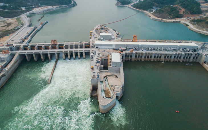
Xayaburi Dam from a bird-eye view. Photo: XPCL.
In the past week, inundations in the Mekong River at Tan Chau and Chau Doc have been decreasing and are at a low level. On August 13, the highest daily water level in Tan Chau was 1.99 meters, while the highest daily water level in Chau Doc was 1.79 meters. The water level is expected to rise by an average of 5.0 cm per day over the next five days, in accordance with the high tide trend.
The upstream Mekong River flood is presently at a low level, only slightly higher than the same period in 2019 but lower than the same period in 2015 and significantly lower than the same period in 2022 and the long-term average. The assessment that the impact of the discharge of the Xayaburi dam in Upper Laos, which raises the water level of the Mekong River headwaters in Tan Chau by only 3 to 5 centimeters, is therefore not concerning and deemed insignificant.
Approximately 1,657 kilometers from the Vietnam-Cambodia border, the Xayaburi Dam is the first hydropower facility on the Mekong River's main stem in the lower basin. The construction of the project in Upper Laos began in 2012, was concluded in 2017, and will commence in October 2019.
The dam's design parameters include: The average incoming flow is 3,990 m3/s; the electricity-generating water column is 32,5 m; the turbine flow is 5,000 m3/s; the unit number is 8; the installed capacity is 1,280 MW; the normal water level rise is 275 m; the deceased water level is 270 m; the useful capacity is 225 million m3; and the annual electricity output is 7,406 (GWh).
The Mekong River Commission (MRC) Secretariat reported earlier this month that water levels in the Lower Mekong River Basin (LMB) have risen swiftly and are expected to rise further over the next five days, particularly from Chiang Khan to Khong Chiam in Thailand and Vientiane to Savannakhet in Lao PDR, reported by the ASEAN Post.
According to the MRC's observed water levels and rainfall data, significant rainfall in the Mekong region, which began on 5 August, has contributed to the rise, causing the river levels at the majority of monitoring stations to exceed their long-term averages.
The river level in Vientiane, the capital of Laos, rose by 4.30 meters over the same time period, a rise of roughly 40 percent. The river level is expected to rise between 2.34 m and 3.32 m over the next five days. The increase will place the station level in the alarm state (11.5 m), which is lower than the flood warning threshold of 12.5 m.
Due to tidal effects, the water levels in Tan Chau on the Mekong River and Chau Doc on the Bassac River in Vietnam's Mekong Delta fluctuated and remained below their long-term averages.
Translated by Linh Linh

(VAN) As floodwaters recede, a vast network of irrigation works across eastern Gia Lai is emerging in a state of severe disrepair, with extensive damage demanding urgent restoration ahead of the 2025-2026 winter-spring cropping season.

(VAN) The conference reviewing three years of implementing Decision 911 identified the need to prioritize improving marine environmental quality and promoting sustainable fisheries development.

(VAN) Le Hoai Trung, Member of the Communist Party of Vietnam Central Committee and Minister of Foreign Affairs, held talks with Vi Thao, Chairman of the Guangxi Zhuang Autonomous Region (China) this week.

(VAN) The Mekong River Commission adopts the 2026 - 2030 Strategic Plan with a people-centered approach.
/2025/11/26/1720-1-200855_132.jpg)
(VAN) Viet Nam and Japan have many conditions to expand cooperation on climate change adaptation, particularly in disaster risk management based on advanced technologies.

(VAN) The strong development of digital technology and artificial intelligence is opening up opportunities to transform science and technology into a 'Magic eye' for disaster forecasting and early warning.

Applying vaccines and proactive disease prevention helps pig herds stay healthy, maintain productivity, reduce risks, and decrease reliance on antibiotics in modern livestock farming.
