December 1, 2025 | 08:49 GMT +7
Hotline: 0913.378.918
![]()
December 1, 2025 | 08:49 GMT +7
Hotline: 0913.378.918
![]()
In early April 2025, a group of experts from the Southern Irrigation Planning Institute conducted a survey trip in five coastal provinces of the Mekong Delta, including: Tien Giang, Ben Tre, Tra Vinh, Soc Trang, and Bac Lieu.
One alarming issue highlighted by experts is the widespread land subsidence, with an average rate of 10-30 mm per year, and in some areas, it reaches 20-30 mm per year.
Land subsidence exacerbates the impact of rising sea levels, increasing the depth of flooding and, in particular, accelerating the erosion process along the coast.

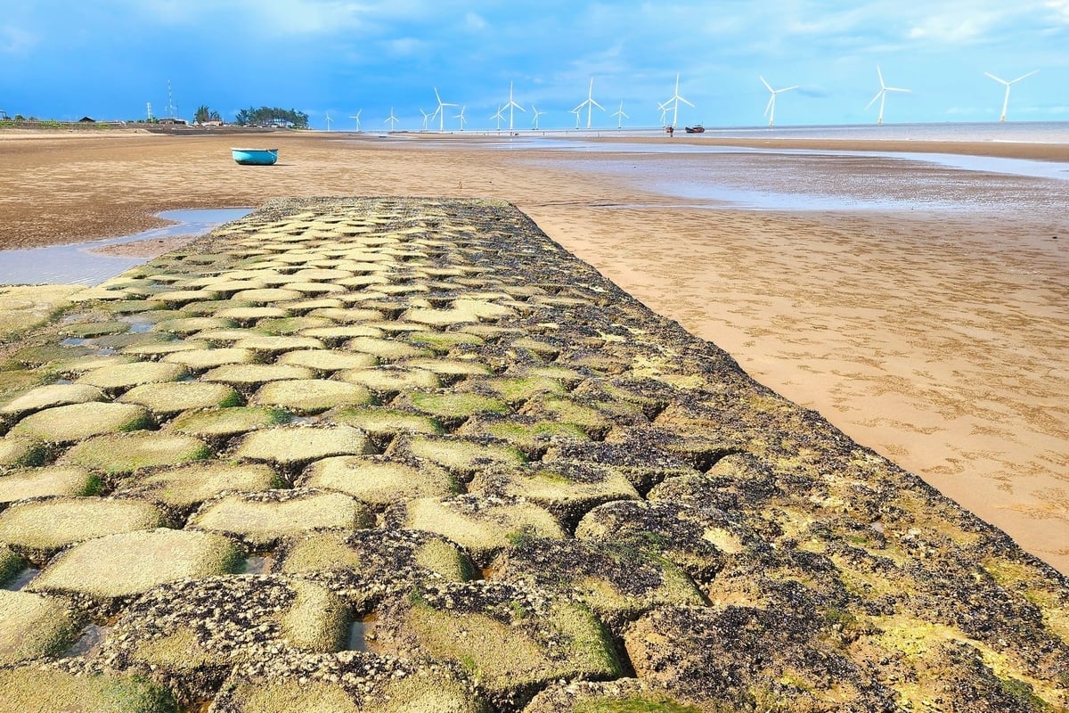
Current state of coastal dikes in some localities of the Mekong Delta. Photo: Kim Anh.
Mr. Tran Quang Tho, an expert from the Southern Irrigation Planning Institute, reported that approximately 50% of the total 720 km of coastline in the Mekong Delta is being eroded, causing the loss of nearly 300 hectares of land per year on average, and this trend is forecast to continue increasing. Among them, more than 70 km of coastline is eroding at a very fast rate, from 20-50 meters per year, with 17 areas experiencing severe erosion.
The combined effects of these issues are leading to the degradation of mangrove forests, which are an important natural defense line for coastal localities in the Mekong Delta.
The survey results also show that mangrove forests are severely degraded and shrinking in many areas. Around 242 km of coastline with mangrove forests is experiencing erosion at a rate of 10-40 meters per year, with the remaining width of the forest under 500 meters, which is insufficient to effectively reduce wave energy, posing a threat to the safety of the inland coastal dikes.
According to the 2024 report on the current state of forests in the five localities and the field survey results, the Southern Irrigation Planning Institute concluded that by the end of 2024, the area of coastal protective forests and the forest coverage rate in these areas will be low compared to the requirements for protecting the long coastline.
In 2024 alone, nearly 131 hectares of forest have been lost due to erosion and related natural factors in Tra Vinh, Ben Tre, Soc Trang, and Tien Giang. This data highlights that erosion has become an ongoing and imminent threat to the existence of coastal protective forests.
One of the coastal dike sections in Tra Vinh province. Photo: Kim Anh.
In reality, in Tra Vinh, about 750 meters of coastal protection dike in the Con Trung area, Truong Long Hoa commune (Duyen Hai town), have shown signs of slight subsidence, with cracks ranging from 5-7 cm.
The Go Cong coastal area (Tien Giang province) is also experiencing severe erosion, especially in the Phuoc Cung area (Tan Thanh commune) and Moi Hamlet (Tan Dien commune), where the sea is encroaching right up to the base of the dike. On average, the area loses about 15 hectares of forest per year.
In Ben Tre, 19 km of the total 65 km of coastline is severely eroded. The average erosion rate is 20-25 meters per year. Among them, Thanh Phu and Binh Dai districts are most affected in terms of land and forest loss.
In Soc Trang, the Vinh Chau coastal dike, located in Lai Hoa commune, which borders Bac Lieu province, is also experiencing severe erosion. Coastal waves are causing erosion right up to the dike structure. The protective forest is either no longer present or is very thin. The locality has constructed a centrifugal dike with two rows of piles, with a top elevation exceeding 2.8 meters, to absorb waves and promote sediment deposition.
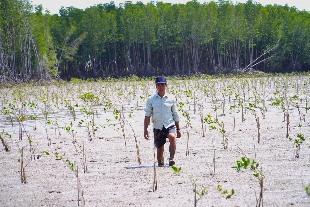
Replanting and protecting existing forest areas is a nature-based solution that is commonly implemented in the Mekong Delta. Photo: Kim Anh.
In Bac Lieu province, most of the embankment projects have been completed. However, some major projects, such as the submerged dike in Nha Mat and Hoa Binh, are still under construction. There are concerns about the potential for slope erosion in certain sections of the coastal dikes during extreme weather conditions due to the lack of protective structures in front of them.
In response to these challenges, coastal localities are focusing on protecting the coastline, restoring mangrove forests linked to biodiversity conservation, and ensuring livelihoods for local people.
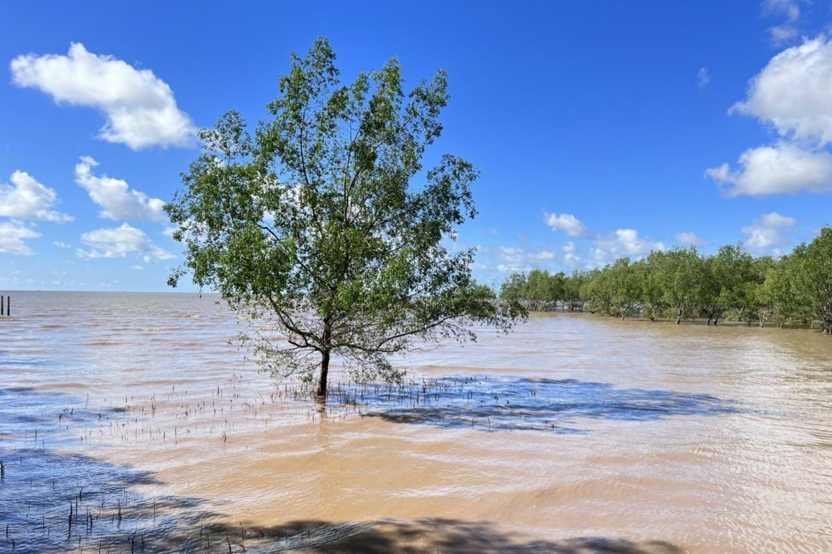
The protective forest belt outside the dike is in a fragile state, facing great pressure from erosion and human activities. Photo: Kim Anh.
To address this, localities are focusing on replanting, regenerating, and protecting existing mangrove forests with technical and financial support from international projects.
At the same time, the provinces are also researching and considering the potential application of nature-based solutions, such as developing Integrated mangrove-shrimp (IMS) aquaculture models, using the infrastructure to reduce waves and promote sediment deposition, and employing hollow dikes to reduce waves and indirectly support the restoration of natural forests inland.
Experts assess that nature-based solutions have great potential in sustainably protecting the coastline and providing cost-effective results. However, large-scale implementation remains very limited due to the lack of integrated spatial planning, conflicts of interest, especially regarding land use rights granted for aquaculture, insufficient policy mechanisms to encourage action, as well as technical limitations and community awareness issues.
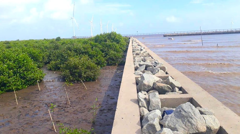
A forest has formed on the area inside the submerged dike in Lai Hoa commune, Vinh Chau town, Soc Trang province. Photo: Kim Anh.
Therefore, the Southern Irrigation Planning Institute recommends that localities continue to invest in the restoration and replanting of coastal protective forests.
Authorities need to resolve issues related to land allocation, water surface rights, taxes, and administrative boundaries, creating favorable conditions for cooperatives and local people.
It is essential to enhance capacity and provide additional support for sustainable production techniques, while ensuring the timely dissemination of information on water quality, diseases, extreme weather conditions, and market trends to the public.
In particular, a comprehensive study should be conducted to assess the environmental impacts in the river mouth and coastal areas, identifying the causes of fluctuations in salinity, silt, and seabed erosion. This will serve as a basis for proposing appropriate solutions tailored to the specific characteristics of each region.
Translated by Kieu Chi

(VAN) The inevitable path forward is to reorganize production along the value chain, utilizing cooperatives as the core, enterprises as the driving force, and farmers as the central subjects.

(VAN) On November 28, Minister Tran Duc Thang, together with China's Minister of Agriculture and Rural Affairs Han Jun, chaired the 2nd meeting of the Viet Nam - China Agricultural Cooperation Committee.

(VAN) Forest carbon credits are only accepted when they ensure absolute environmental integrity, additionality, permanence, and transparency.

(VAN) Viet Nam partners with Beijing on controlling air pollution, cross-regional management, high-tech monitoring and relocating polluting facilities.

(VAN) With a USD 50 million investment, Australia is partnering with Viet Nam to operate its first public electric bus fleet and develop a nationwide EV charging network.

(VAN) On November 28, in Beijing, Minister Tran Duc Thang met Minister of Ecology and Environment of China Huang Runqiu, to share experience on environmental protection.
/2025/11/28/0950-2-120557_751.jpg)
(VAN) The recent flood spell in the South Central region clearly reflects the characteristics of natural disasters in 2025, which are compound, prolonged, and amplified.
