November 28, 2025 | 06:50 GMT +7
Hotline: 0913.378.918
![]()
November 28, 2025 | 06:50 GMT +7
Hotline: 0913.378.918
![]()
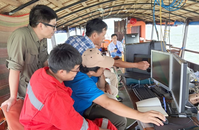
Mr. Hoang Viet, Freshwater Program Manager and Sustainable Sand Mining Project Director (behind, wearing glasses), working with the technical team. Photo: Ngoc Thang.
At the invitation of the World Wide Fund For Nature (WWF) Vietnam’s Sustainable Sand Mining Project, I accompanied the delegation to "endoscope" the river to find sand. After more than half a month of drifting on a ship around many monitoring points on downstream Mekong, the delegation arrived at the Hau river section in the Tra Noc area (Can Tho).
Ten people were divided into three groups to handle the work on this technical ship. “Uncle Hai”, a steersman from Vinh Long who has a lot of experience in his job, said this after more than half a month onboard: “I was a bit confused at first, but now I'm used to it. The ship is full of equipment, so after performing the task we must find a safe place to anchor.”
Mr. Hoang Viet, Freshwater Program Manager and Sustainable Sand Mining Project Director, said that the computer system was firmly installed on the ship to avoid shaking when facing big waves at work. A technical device mounted deep under the water was attached to the sides of the ship to transmit the endoscope’s signal into the computer system for processing.
Uncle Hai's task was to drive the ship according to the correct positioning and speed displayed on the computer screen placed in front of the steering wheel. The ship must go straight through each row like the lines in a notebook. The endoscopy of this section of the Hau river was about 1.5 km. There was a total of approximately twenty survey lines along this part of the river, following a scanning route from one riverbank to the other.
Ten people were divided into three groups to handle the work on this technical ship. Photo: Ngoc Thang.
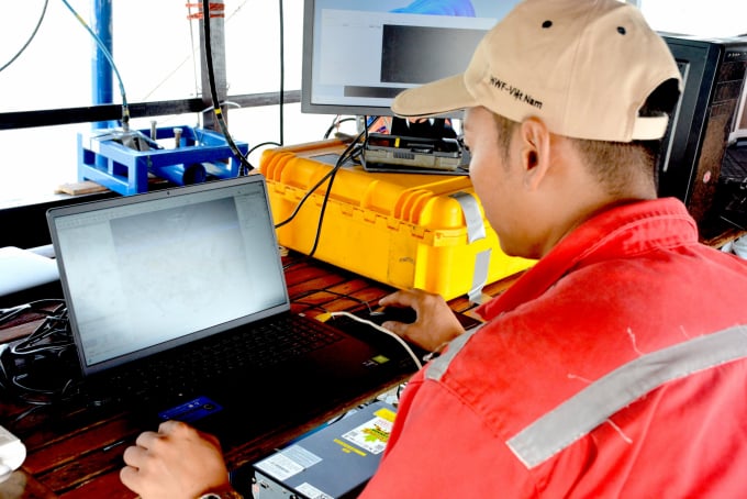
It took approximately six hours to perform the endoscopy of this riverbed. After taking some pictures I was invited by Mr. Ha Huy Anh, Sustainable Sand Mining Project National Director, to sit in front of the computer screen to see photos and data. He then explained some technical knowledge about the path of sand grains.
‘Surveying the movement of sand dunes is one of several activities aiming to construct a “resource bank” of the sand in the Mekong Delta. The aim of this research bank is to study the balance between the amount of sand flowing into the delta from the upper Mekong River, the amount of sand mined in the delta and the amount of sand discharged into the sea. So this is one of three measurement activities on two tributaries of the Tien and Hau rivers. There are also "hydrodynamic and sedimentary" surveys and "sand reserve" surveys to complete the sand “bank” for the Mekong Delta.’
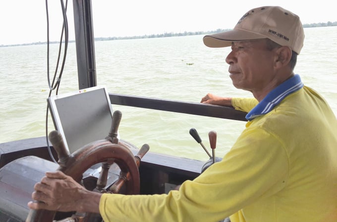
Whenever we saw a large ship going in the opposite direction, Uncle Hai would blow a long horn so that everyone could notice. Photo: Ngoc Thang.
Mr. Ha Huy Anh hovered his mouse over a 3D computer image transmitted directly from the endoscope and explained, “This sand dune is approximately 40 m long. The area belongs to a section on the Hau river, so there are still many sand dunes.”
I was not an expert, so when I looked at these sand dunes I thought of the terraced fields on plateaus. The sand dunes in the riverbed were as beautiful as a picture that I have never seen before. I was in awe.
But when Mr. Ha Huy Anh showed another 3D computer image of the sand dunes downstream of My Thuan bridge on Tien river captured by the endoscope over the past few days, I thought of lungs suffering from cancer from smoking too much. It looked horrible.
"We are exploiting sand in a ‘dredging until the end’ fashion, deep under the sand dunes on the riverbed, and taking away four times the amount of sand arriving from upstream every year," said Mr. Ha Huy Anh.
The situation has worsened as the amount of sand from upstream has become less and less due to the construction of many hydroelectric dams on the Mekong in recent years. Sand and sediment has built up in front of the hydroelectric dams, so only a little sand and sediment can flow downstream when upstream the floodgates are opened. Grains of sand arriving at Tan Chau, An Giang (near the border of Cambodia), move with the water flow to My Thuan (on the Tien river) and Can Tho (the Hau river).
Translated by Samuel Pham

(VAN) According to Mr. Vo Minh Thanh, Director of the Tay Ninh Department of Agriculture and Environment, Resolution 57 has created a new development pathway for the locality, shifting from traditional toward modern agriculture.
/2025/11/26/4909-2-154329_878.jpg)
(VAN) Pearl grouper farming in HDPE cages not only delivers economic efficiency but also contributes to protecting the environment, creating jobs, and promoting marine-based experiential tourism.

(VAN) The model of making a living under the forest canopy through the agroforestry system in Van Son commune, Bac Ninh province, is expected to generate an annual income of approximately VND 30 million/ha.

(VAN) Many enterprises in Can Tho are harnessing natural energy and reducing greenhouse gas emissions in their production processes, thereby contributing to the promotion of a sustainable green transition.
/2025/11/24/3536-2-112800_176.jpg)
(VAN) Dong Nai now has tens of thousands of hectares of forests certified for sustainable management, and this area will continue to be expanded in the coming period.

(VAN) Vinh Ha hamlet (Dai Xuyen commune, Hanoi) is shifting away from small-scale farming as households adopt bioscurity into their breeder chicken models.

(VAN) Heavy rains make aquatic species more vulnerable to disease. Proactive water management and high-tech systems help farmers prevent outbreaks and protect yields.
