November 27, 2025 | 09:25 GMT +7
Hotline: 0913.378.918
![]()
November 27, 2025 | 09:25 GMT +7
Hotline: 0913.378.918
![]()
Deputy Minister of Natural Resources and Environment Le Cong Thanh has just signed Decision No.552 on Promulgating the Plan to implement the Early Warning Project for landslides and flash floods in mountainous and midland areas of Vietnam as a basis for assigning direct relevant units under the Ministry to implement the contents and tasks in Decision No.1262 of the Prime Minister.
Accordingly, will focus on building an early warning information system and a synchronous, comprehensive medium-scale and large-scale risk zoning map system while providing and exchanging warning information with the residential community; Strengthen the natural disaster response capacity of local officials and people through the Project's results transfer, training, and communication activities;
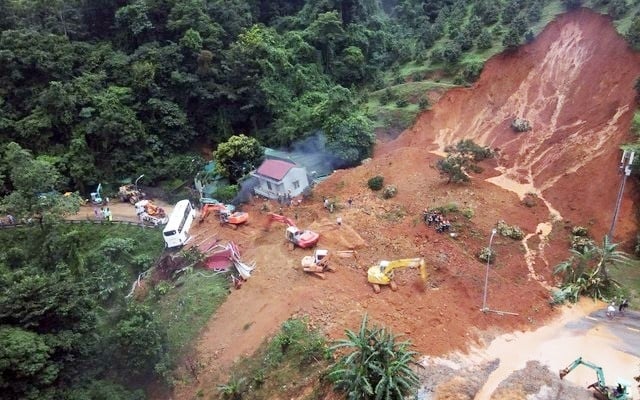
Landslide in Bao Loc (Lam Dong province). Photo: VGP.
Close coordination between units from central to local levels during the implementation process; Promote community participation in providing information for early warning of landslides and floods; limit the increased risk of landslides and flash floods.
Inherit, integrate and deploy this Pplan with the implementation of the program to update natural disaster risk zoning and create natural disaster warning maps, especially for natural disasters related to storms and rising water levels caused by natural disasters, floods, flash floods, landslides, drought, saltwater intrusion (Program 705) and approved programs, plans, schemes and projects with content consistent with goals and tasks in Decision No.1262 of the Prime Minister.
Strengthen international cooperation, especially with developed countries in science and technology, to improve capacity and ability to research and apply advanced science and technology in zoning and early warning of landslides flash floods in mountainous and midland areas of Vietnam, and also take advantage of the technical and financial support of countries and international organizations for early warning of landslides and flash floods.
The Project's products will be transferred to authorities and people in areas at risk of landslides and flash floods to improve communication capacity and use early warning information to serve prevention and control. Avoid landslides and flash floods in the community, and reduce damage caused by landslides and flash floods.
According to the Plan, the Ministry of Natural Resources and Environment requires reviewing and developing a complete system of legal documents, processes and technical regulations to serve the implementation of tasks related to zoning and early warning of natural disasters, flash floods;
Establish and maintain operation of the information system - early warning of landslides and flash floods; Investigate, build data sets, create status maps, risk zoning maps, and risk zoning due to landslides and flash floods (scale 1:10,000 and larger) for 150 high-risk areas, with priority given to areas at risk of complex natural disasters such as landslides and flash floods.

Landslides and flash floods in Mu Cang Chai (Yen Bai province). Photo: XD.
Investigate, build data sets, create current status maps, risk zoning maps, risk zoning due to landslides and flash floods (scale 1:50,000 and scale 1:25,000) for 37 central provinces of Vietnam's tourist and mountainous areas; applying science and technology and international cooperation in early warning of landslides and flash floods; improve community capacity in communication and use of early warning information; Review and develop a complete system of legal documents, processes and technical regulations to serve the implementation of tasks related to zoning and early warning of natural disasters like landslides and flash floods.
Develop and complete economic-technical norms for investigation, detailed surveys, mapping, and large-scale risk zoning of landslides and flash floods.
Complete the shared database system to serve early warnings of landslides and flash floods; Upgrade and develop landslide and flash flood warning models for 37 midland and mountainous provinces of Vietnam; Build an information system - early warning of landslides and flash floods in real-time, with coordination between management agencies, warning and forecasting agencies and people in receiving, data information analyzing and processing; Trial operation at the central government and 37 midland and mountainous provinces.
Create hazard zoning maps and natural disaster risk zones due to landslides and flash floods (scale 1:50,000 and scale 1:25,000) for 15 provinces, including 3 provinces in the Northern region (Phu Tho, Vinh Phuc, Thai Nguyen), 5 provinces in the Central region (Binh Dinh, Phu Yen, Khanh Hoa, Ninh Thuan, Binh Thuan), 5 provinces in the Central Highlands (Kon Tum, Gia Lai, Dak Lak, Dak Nong, Lam Dong) and 2 provinces in the Southeast region (Binh Phuoc, Dong Nai);
The Ministry of Natural Resources and Environment recommends that during the implementation process, it is necessary to review and inherit the results and products of relevant programs, schemes, projects and topics to ensure economical and effective implementation; proactively coordinate with ministries, branches, localities, people and businesses in implementing the Plan's contents; Arranging population stabilization, evacuating and relocating people from natural disaster areas to meet urgent requirements in preventing, combating and responding to risks of flash floods and landslides.
Translated by Tuan Huy

(VAN) After the institutional merger, Da Nang possesses significant forest-carbon reserves and is proactively engaging in the carbon market, creating a new revenue stream.

(VAN) An Giang strengthens communication against IUU fishing, increases inspections and sanctions, and is determined to remove the EC’s “yellow card” while developing a sustainable fisheries sector.

(VAN) As green transition becomes a global trajectory, Viet Nam’s biggest challenge is not only technology and models, but how to ensure that capital flows reach the right beneficiaries.

(VAN) The Ministry of Agriculture and Environment must spearhead the construction of green governance, spanning decision-making processes and investment standards to policy evaluation mechanisms.

(VAN) The Agriculture and Environment sector of Khanh Hoa has achieved numerous milestones over the past 80 years, contributing significantly to the goal of establishing the province as a centrally governed city by 2030.

(VAN) Viet Nam is entering the pivotal period of 2025-2030, moving toward the formulation of the Remote Sensing Law, which will establish a legal foundation for the development of national digital data.

(VAN) The agricultural sector is finalizing the strategic framework for emission reduction, setting the goal of sharply cutting methane and 403.7 million tons of CO2 equivalent and moving toward Net Zero by 2050.
